UPSC PRELIMS+MAINS
A) Science and Technology, Defence, Space
1. PUSA Decomposer (TH)
- Context: The Union government is testing an innovative method, the PUSA Decomposer, developed at the Indian Agricultural Research Institute, Pusa, as an alternative to stubble burning.
Analysis
- The PUSA Decomposer is a set of four tablets made by extracting at least eight types of fungi strains, which assist in producing enzymes (to digest cellulose, lignin and pectin in paddy straw) essential to quicken the decomposition of bio-mass/ paddy straw.
- It reduces the decomposition time of shredded and watered paddy straw from around three months to just 25 days.
- Termites are used in order to generate the necessary fungi to decompose the stubble.
- Termites themselves attack crop produce in India, causing havoc in an indiscriminate manner.
- Then, why buy extra trouble, but simply isolate the microorganisms which produce the necessary enzymes for decomposing the stubble? It was with this logic that IARI seems to have come up with its Pusa Decomposer formula.
- ‘Pusa Decomposer’ capsules need to be dissolved in water containing jaggery and chickpea flour.
- This is then fermented for three-to-four days, and the liquid so obtained is ready to be sprayed in the farmers’ field in order to decompose the left-over biomass.
- Four such capsules are enough to make 25 litres, which can be used to decompose the crop residue per hectare of the field.
- The stubble gets converted into manure in the field and add to the nutrition in the soil.
- Incidentally, it is interesting to note that food grains produced using the Pusa Decomposer qualify as organic farming, since it involves no growth hormones, antibiotics, no genetically modified organisms, and no leaching of surface water or ground water.
- It is completely organic and chemical free.
- The biggest advantage of this technology is that it prevents burning of crop residue.
- It works best when the soil is dug up so that the decomposer can act on both the stubble and the roots.
- While the decomposer is being seen as a solution to the problem of burning of ‘parali’ or rice straw, it can actually be used for speeding up the decomposition of any kind of biomass.”
- Wheat can also be planted in unploughed fields with straw and stubble retained in them.
- The only requirement is that the straw be chopped and spread evenly across the field after threshing.
- Seed drills called the Happy Seeders cut five-cm deep slits in straw-covered fields and sow wheat seeds.
- The retained straw conserves soil moisture and suppresses weeds.
- It degrades in five to six months on its own.
- There is an apprehension that in fields where straw is mixed with the soil, microbes, including fungi, will compete with plants for nitrogen when they digest the straw. This can affect plant growth and yield.
- Hence, farmers are advised to apply urea while sowing, and not later at the time of irrigation.
- “The entire Andhra Pradesh grows rice but they do not burn stubble, the entire Karnataka grows rice, Bihar grows rice, none of them burn stubble,” he said. “The stubble burning is coming because of the wheat… that is where the problem lies. We need to move away from the rice and wheat system.”
- When the rice is harvested, straw and stubble is left behind. With no cost-effective and environmentally-friendly way to clear their fields in time to sow wheat for the winter season, farmers resort to burning the crop stubble.
- As field trials in the northwestern region have been found successful, Pusa Decomposer should be tried in areas of Northeast India where ‘slash and burn’ (locally called ‘jhum’) is still followed.
2. Leishmaniasis or Kala-azar (TH)
- Context: Kala-azar has been eliminated from a highly endemic district (Vaishali) in Bihar.
Analysis
- Kala-azar or visceral leishmaniasis (VL) is a tropical disease characterised by irregular fever, weight loss, anaemia and swelling of the spleen and liver.
- It is caused by a protozoan Leishmania parasite and is transmitted to humans by the bite of infected female sandflies.
- According to the World Health Organisation (WHO), globally, about 7 to 10 lakh new cases occur annually.
WHO initiative
- India accounts for about two-thirds of the total global cases, and the disease is endemic to Bihar, Jharkhand, Uttar Pradesh and West Bengal.
- An initiative was launched by WHO to eliminate VL as a public health problem from the South East Asia region by 2020.
- The deadline has now been extended to 2023.
- We call a disease eliminated when the annual incidence is reduced to less than 1 case per 10,000 people at the sub-district or block level.
- Eradication would mean there are zero cases.
- The disease is not contagious.
- Rroutine monitoring is needed to identify if the Kala-azar vector has developed resistance to insecticides.
- For full details, refer to 5th Nov file.
3. Twice hit by climate change: Global warming may have killed many dinosaurs 179 MYA (TH)
- Context: Most people know that land-dwelling dinosaurs were wiped out some 66 million years ago when a huge asteroid crashed into Earth.
- New research says, more than 100 million years earlier, another climate change cataclysm – a global warming – devastated a different set of dinosaur species, with many going extinct.
Analysis
- Scientists have found evidence of this traumatic event some 179 million years ago in plant fossils in Argentine Patagonia.
- Patagonia is the semiarid scrub plateau that covers nearly all of the southern portion of mainland Argentina.
Dinosaur discovered
- They also discovered a previously unknown dinosaur, named Bagualia alba. This is in the family of massive, long-necked sauropods, the largest animals to walk the Earth.
- Before the global warming event, sauropods were only one branch of the Sauropodomorpha lineage.
- Other dinosaurs in the same group were smaller and lightly built, with some no bigger than a goat.
- But a series of volcanic eruptions over several million years released huge amounts of CO2 and methane in the atmosphere, warming the planet and transforming the vegetation dinosaurs fed on.
- The climate went from a temperate, warm and humid with a diverse lush vegetation to a strongly seasonal, hot-and-dry regime.
- Smaller Sauropodomorpha dinosaurs were unable to cope with the change, but larger sauropods – like Bagualia alba – thrived.
- Sauropods were massive, four-legged animals with long necks, which meant they could reach the tops of trees.
- Their very robust mandibles and spoon-shaped teeth were adapted to feed on all kinds of plants such as conifer trees.
- Sauropods’ new diet saw them expanded in size from 10 metres to 40 metres in length, as large digestion chambers were needed to cope.
- They became the dominant group of herbivores and eventually the largest animals to ever walk the Earth.
4. Tree rings may hold clues to impacts of distant supernovas on Earth (TH)
- Context: A new study, published this month in the International Journal of Astrobiology, probes the impacts of supernovas, some of the most violent events in the known universe, on our planet’s biology and geology.
- In the span of just a few months, a single one of these eruptions can release as much energy as the sun will during its entire lifetime.
Analysis
- We see supernovas in other galaxies all the time.
- Through a telescope, a galaxy is a little misty spot. Then, all of a sudden, a star appears and may be as bright as the rest of the galaxy.
- A very nearby supernova could be capable of wiping human civilization off the face of the Earth. But even from farther away, these explosions may still bath our planet in dangerous radiation and damaging its protective ozone layer.
- To study those possible impacts, scientists searched through the planet’s tree ring records for the fingerprints of these distant, cosmic explosions.
- The findings suggest that relatively close supernovas could theoretically have triggered at least four disruptions to Earth’s climate over the last 40,000 years.
Radiocarbon spikes
- The research hinges on the case of a curious atom. Carbon-14, also known as radiocarbon, is a carbon isotope that occurs only in tiny amounts on Earth.
- It’s not from around here, either. Radiocarbon is formed when cosmic rays from space bombard our planet’s atmosphere on an almost constant basis.
- Trees pick up carbon dioxide and some of that carbon will be radiocarbon.
- Sometimes, however, the amount of radiocarbon that trees pick up isn’t steady.
- Scientists have discovered a handful of cases in which the concentration of this isotope inside tree rings spikes — suddenly and for no apparent earthly reason.
- Many scientists have hypothesized that these several-year-long spikes could be due to solar flares or huge ejections of energy from the surface of the sun.
- Scientists have recorded supernovas in other galaxies that have produced a stupendous amount of gamma radiation — the same kind of radiation that can trigger the formation of radiocarbon atoms on Earth.
- While these isotopes aren’t dangerous on their own, a spike in their levels could indicate that energy from a distant supernova has traveled hundreds to thousands of light-years to our planet.
- To test the hypothesis, scientists turned to the past. They assembled a list of supernovas that occurred relatively close to Earth over the last 40,000 years.
- Scientists can study these events by observing the nebulas they left behind.
- They then compared the estimated ages of those galactic fireworks to the tree ring record on the ground.
- They found that of the eight closest supernovas studied, all seemed to be associated with unexplained spikes in the radiocarbon record on Earth.
- Some astronomers think they’ve picked up signs that Betelgeuse, a red giant star in the constellation Orion, might be on the verge of collapsing and going supernova and it’s only 642.5 light-years from Earth.
5. Hurricanes are lasting longer, staying stronger, over land (TH)
- Context:Hurricanes could be lasting longer after they make landfall, and spreading their damage farther inland, a new study suggests—a previously undescribed effect of climate change.
- The study authors say warming ocean temperatures are the driving force behind this longer lifespan.
- The warmer the sea surface temperature, the more moisture a storm carried over land and the longer it took to decay.
- Warm air holds more moisture than cool air, and a number of previous studies have shown a clear link between climate change and hurricanes that dump more rain.
Analysis
Tropical Cyclone
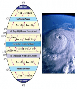
- A tropical cyclone is an intense low-pressure area or a whirl in the atmosphere over tropical or sub-tropical waters, with organised convection (i.e. thunderstorm activity) and winds at low levels, circulating either anti-clockwise (in the northern hemisphere) or clockwise (in the southern hemisphere).
- From the centre of a cyclonic storm, pressure increases outwards.
- The amount of the pressure drop in the centre and the rate at which it increases outwards gives the intensity of the cyclones and the strength of winds.
How do cyclones form?
- Tropical cyclones require certain conditions for their formation. These are:
- A source of warm, moist air derived from tropical oceans with sea surface temperature normally near to or in excess of 27 °C;
- Winds near the ocean surface blowing from different directions converging and causing air to rise and storm clouds to form;
- Winds which do not vary greatly with height – known as low wind shear/wedge. This allows the storm clouds to rise vertically to high levels;
- The disturbance must occur at a minimum distance of at least 500 km [300 mi] from the equator. For tropical cyclonic storms to occur, there is a requirement that the Coriolis force must be present.
- Coriolis force/spin induced by the rotation of the Earth that can prevent filling of low pressure at the centre.
- Remember that the Coriolis effect is zero near the equator and increases to the north and south of the equator.
- Without the Coriolis force, the low pressure of the disturbance cannot be maintained (absence of Coriolis force near the equator prohibits the formation of tropical cyclone between 0°-5° latitude);
- Unstable condition through the troposphere that creates local disturbances around which a cyclone develops;
- The atmosphere must cool fast enough with height, such that it is potentially unstable to moist convection. It is the thunderstorm activity which allows the heat stored in the ocean waters to be liberated and used for tropical cyclone development.
- Since the main source of energy for the storm is the heat contained in the warm tropical and subtropical oceans, if the storm moves over the land, it is cut off from its source of heat and will rapidly begin to dissipate.
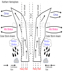
Structure of Tropical Cyclones
Coriolis Force
- The invisible force that appears to deflect the wind is the Coriolis force.
- It is determined by the mass of the object and the object’s rate of rotation.
- The Coriolis force is perpendicular to the object’s axis.
- The Earth spins on its axis from west to east. The Coriolis force, therefore, acts in a north-south direction.
- The Coriolis force is zero at the Equator and maximum at the poles.
- Winds blow across the Earth from high-pressure systems to low-pressure systems. However, winds don’t travel in a straight line. The actual paths of winds—and of ocean currents, which are pushed by wind—are partly a result of the Coriolis effect.
- The key to the Coriolis effect lies in the Earth’s rotation. The Earth rotates faster at the Equator than it does at the poles. This is because the Earth is wider at the Equator. A point on the Equator has farther to travel in a day.
- This apparent deflection is the Coriolis effect. The wind is like the ball. It appears to bend to the right in the Northern Hemisphere. In the Southern Hemisphere, winds appear to bend to the left.
- In the Northern Hemisphere, wind from high-pressure systems pass low-pressure systems on the right. This causes the system to swirl counter-clockwise.
- Thus, the hurricanes and other storms swirl counter-clockwise in the Northern Hemisphere. In the Southern Hemisphere, storms swirl clockwise.
Naming of Cyclones
- Tropical cyclones are named to provide ease of communication between forecasters and the general public regarding forecasts and warnings.
- In most regions pre-determined alphabetic lists of alternating male and female names are used.
- However, in the north-west Pacific the majority of names used are not personal names.
- While there are a few male and female names, majority are names of flowers, animals, birds, trees, foods or descriptive adjectives.
- The names of cyclones in Indian Seas are not allocated in alphabetical order, but are arranged by the name of the country which contributed the name.
- It is usual practice for a storm to be named when it reaches tropical storm strength.
- The first name in any given year is the one immediately following the last name from the previous year.
Tropical Cyclones: Classification
- As per the criteria adopted by the World Meteorological Organisation (W.M.O.), India Meteorological Department classifies the low pressure systems in the Bay of Bengal and in the Arabian Sea into 7 classes.
- Low pressure areas with maximum sustained surface winds of speed between 31 & 61 km.p.h. are called tropical depressions.
- Once the winds around the low pressure area reach at least 62 km.p.h, it is called a tropical cyclone and is assigned a name.
- When wind speed is between 89 & 118 km.p.h it will be a Severe Cyclonic Storm (SCS), between 119 & 221 km.p.h (64 & 119 kt) it is Very SCS and when exceeds 221 km.p.h (119 knots), the cyclone is called a Super Cyclonic Storm.
| Type of Disturbances | Associated Wind Speed in the Circulation |
| Low pressure Area | Less than17 knots (<31 kmph) |
| Depression | 17 to 27 knots (31 to 49 kmph) |
| Deep Depression | 28 to 33 knots (50 to 61 kmph) |
| Cyclonic Storm | 34 to 47 knots (62 to 88 kmph) |
| Severe Cyclonic Storm | 48 to 63 knots (89 to 118 kmph) |
| Very Severe Cyclonic Storm | 64 to 119 knots (119 to 221 kmph) |
| Super Cyclonic Storm | 119 knots and above (221 kmph and above) |
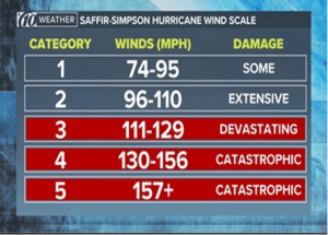
Saffir-Simpson Hurricane Scale
- The Saffir-Simpson Hurricane Scale is used to rate hurricane intensity in the Atlantic Basin.
- A 1-5 rating system is used based on a hurricane’s sustained wind speed, with Category 1 being a less intense storm and Category 5 very intense.
- This scale estimates potential property damage. Hurricanes reaching Category 3 and higher are considered major hurricanes because of their potential for significant loss of life and damage.
- Category 1 and 2 storms are still dangerous, however, and require preventative measures.
- In the western North Pacific, the term “super typhoon” is used for tropical cyclones with sustained winds exceeding 150 mph.
Cyclonic Storm – Four Stage Warning
- The cyclone warnings are issued to state government officials in four stages.
- The First Stage warning known as “PRE CYCLONE Watch” issued 72 hours in advance contains early warning about the development of a cyclonic disturbance in the north Indian Ocean, its likely intensification into a tropical cyclone and the coastal belt likely to experience adverse weather.
- This early warning bulletin is issued by the Director General of Meteorology himself and is addressed to the Cabinet Secretary and other senior officers of the Government of India including the Chief Secretaries of concerned maritime states.
- The Second Stage warning known as “CYCLONE ALERT” is issued at least 48 hrs. in advance of the expected commencement of adverse weather over the coastal areas.
- This is issued by the concerned Area Cyclone Warning Centers/Cyclone Warning Centers and Cyclone Warning Division at HQ.
- The Third Stage warning known as “CYCLONE Warning” is issued at least 24 hours in advance of the expected commencement of adverse weather over the coastal areas.
- Landfall point is forecast at this stage.
- The Fourth Stage of warning known as “POST LANDFALL OUTLOOK” is issued by the concerned ACWCs/CWCs/and CWD at HQ at least 12 hours in advance of expected time of landfall.
- It gives likely direction of movement of the cyclone after its landfall and adverse weather likely to be experienced in the interior areas.
- Different colour codes are being used for the different stages of the cyclone warning bulletins.
- Stage of warning Colour code
- Cyclone Alert Yellow
- Cyclone Warning Orange
- Post Landfall Outlook Red
- The special warnings are issued for fishermen four times a day in normal weather and every three hourly in accordance with the four stage warning in case of disturbed weather.
Bomb Cyclone and Bombogenesis
- A winter storm is dubbed a bomb cyclone by meteorologists if it is expected to intensify rapidly.
- By definition, the barometric pressure must drop by at least 24 millibars in 24 hours for a storm to be called a bomb cyclone; the formation of such a storm is called bombogenesis.
- A decrease in pressure intensifies the power of the storm.
- A bombogenesis storm can be tropical or non-tropical.
- Bomb cyclones have been referred to as “winter hurricanes.”
Formation and Development
- Deep drops in barometric pressure occur when a region of warm air meets one of cold air.
- The air starts to move, and the rotation of the earth creates a cyclonic effect.
- The direction is counterclockwise in the Northern Hemisphere (when viewed from above), leading to winds that come out of the northeast.
- Proximity to a large body of water, particularly an ocean, during cold months contributes to the creation of a bomb cyclone.
- The difference in temperature between the normally warmer ocean (particularly in the Atlantic, with the Gulf Stream pumping up warmer water from the south) and the cold landmass often creates the fuel source for powerful East Coast lows.
Do you know?
- In a tropical cyclone, once maximum sustained winds exceed 74 mph, these storms become classified as a hurricane, typhoon, Willy-willy or Cyclone.
- They are all the same thing but are given different names depending on where they appear.
- Hurricanes are tropical storms that form over the North Atlantic Ocean and Northeast Pacific.
- Cyclones are formed over the South Pacific and Indian Ocean.
- Typhoons are formed over the Northwest Pacific Ocean.
- Willy-Willy are formed over the Southwest Australia.
- In the South Atlantic and South Eastern Pacific regions in tropical latitudes, cyclone does not originate. What is the reason? – Inter Tropical Convergence Zone seldom occurs.
When do Tropical Cyclones Recurve?
- In Northern Hemisphere, recurvature of a TC is defined as the situation when a TC transits from a mainly westward track to a northward and sometimes even an eastward track.
- The most prominent reasons for this are upper level trough at mid-latitude and subtropical high pressure belt.
- Besides the above, there are also other factors affecting the TC motion, for example, the interaction of TC with terrain and the presence of other tropical cyclones nearby. All these factors affect each other, making the forecast of TC motion a challenging task.
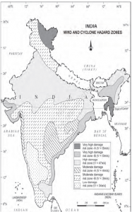
Cyclone Hazard in India
B) Schemes, Policies, Initiatives, Awards and Social Issues
6. UMANG App (PIB)
- UMANG stands for Unified Mobile Application for New-age Governance.
- It is a mobile application to provide secured access to the citizens to multiple government services at one platform.
- It is an all-in-one single, unified, secure, multi-channel, multi-lingual, multi-service mobile app providing access to high impact services of various organizations of Centre and States.
- UMANG was developed by National e-Governance Division (NeGD), Ministry of Electronics & IT.
- UMANG was awarded with the ‘Best m-Government service’ award at the 6th World Government Summit held at Dubai, UAE in Feb 2018.
- Presently, more than 1000 services (from Central and State departments, and Bill payments) are available on UMANG.
- In complete resonance with Digital India’s vision of “Power to Empower”, the aim to develop UMANG was to enable ‘Ease of Living’ for Citizens by facilitating simple and effortless access to major Government services from a single mobile app.
7. UN Population Award
- Context: Gyalyum Sangay Choden Wangchuck, Queen Mother of Bhutan, was announced as the individual laureate for the 2020 United Nations Population Award. HelpAge India was announced as the award’s institutional laureate.
- Established by the United Nations General Assembly in 1981, the United Nations Population Award recognizes contributions in the fields of population and reproductive health. UNFPA serves as its secretariat.
- UNFPA, formally named the United Nations Population Fund, is the United Nations sexual and reproductive health agency.
- The organization was created in 1969, the same year the United Nations General Assembly declared “parents have the exclusive right to determine freely and responsibly the number and spacing of their children.”
UNFPA Supports:
- Reproductive health care for women and youth in more than 150 countries – which are home to more than 80 per cent of the world’s population
- Reliable access to modern contraceptives sufficient to benefit 20 million women a year
- Training of thousands of health workers to help ensure at least 90 per cent of all childbirths are supervised by skilled attendants
- Prevention of gender-based violence, which affects 1 in 3 women
- Abandonment of female genital mutilation, which harms 3 million girls annually
- Prevention of teen pregnancies, complications of which are the leading cause of death for girls 15-19 years old
- Efforts to end child marriage, which could affect an estimated 70 million girls over the next 5 years
- Delivery of safe birth supplies, dignity kits and other life-saving materials to survivors of conflict and natural disaster
- Censuses, data collection and analyses, which are essential for development planning
C) Indices, Reports, Committees and Organisations
8. NCC Celebrates 72nd Anniversary (PIB)
- Context: National Cadet Corps (NCC), the largest uniformed youth organisation in the world, will be celebrating its 72nd Raising Day on 22 Nov 2020.
- The raising day function was marked by paying homage, at the National War Memorial, today, to the fallen heroes, who made the supreme sacrifice of their lives.
Analysis
- Recently, Defence Ministry approved a proposal of the National Cadet Corps (NCC) for a major expansion scheme in all the border and coastal districts.
- A total of one lakh cadets from border and coastal districts will be inducted in the NCC in all three streams of Army, Navy and Air Force.
- One-third of the cadets would be girl cadets.
- More than 1,000 schools and colleges have been identified in border and coastal districts where NCC will be introduced.
National Cadet Corps (NCC)
- National Cadet Corps (NCC), the largest uniformed youth organisation in the world, celebrates its Raising Day on the fourth Sunday of November.
- The National Cadets Corps came into existence under the National Cadet Corps Act XXXI of 1948.
- The nature of the NCC Programme is voluntary and the NCC Programme is a part of the educational activity and not of military activity.
- The motto of NCC is:UNITY AND DISCIPLINE
- A student enrolled into NCC is referred to as a “Cadet”.
- The Aim(s) of NCC are:
- To develop character, commandership, discipline, leadership, secular outlook, spirit of adventure and the ideals of selfless service amongst the youth of the country.
- To create a human resource of organized, trained and motivate youth to provide leadership in all walks of life and always available for the service of the nation.
- To provide a suitable environment to motivate the youth to take up a career in the Armed Forces.
- The Finances/Funds for NCC are shared by the Central and State Govts.
- NCC Song – ‘Hum Sab Bhartiya Hain’
NCC symbol/insignia
- It is the NCC Crest in gold in the middle, with the letters “NCC”; encircled by a wreath of seventeen lotus with a background in Red, Blue and Light blue.
- The colour Red depicts in the NCC Crest depicts the Army. The colours Dark Blue and Light blue in the NCC Crest depict the Navy and the Air Force respectively.
- The Lotus flowers depicts in NCC Crest represent the 17 State Directorates.
- The Ministry of Defence at the National level deals with NCC and Education Ministry deals with NCC in all States.